
References: GIS / Cartography | |||
| 2012 | Saxony, Germany |
Evaluation of regionalisation methods and their geostatistical basics with regard to the assessment of the chemical ground water state (groundwater legislation, literature review, benchmarking test). Client: Saxon State Office for the Environment, Agriculture and Geology (LfULG) |
 |
| 2010-2012 | Brandenburg |
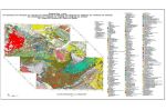
Digitising of the 1:25,000 geological map for the territory of Brandenburg Client: State Office of Brandenburg for Mining, Geology and Resources |
 |
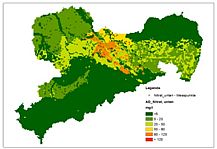
| 2009-2012 | Saxony, Germany |
Contamination maps for urban areas – investigations to enhance the validity of spatial distributions. Client: Saxon State Office for the Environment, Agriculture and Geology (LfULG), Dresden |
 |
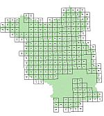
| 2008-2012 | Saxony, Germany |
Digitisation and visualisation of rock facies map Quaternary (LKQ) for almost all the sheets of Saxony*. Client: Saxon State Office for the Environment, Agriculture and Geology * except Eilenburg |
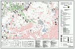 |
| 2011 | Saxony-Anhalt, Germany |
Revision of geological maps for the territory of Saxony-Anhalt as well as digital processing of geological technical documents for the Harz Mountains. Client: State Office for Geology and Mining of Saxony-Anhalt |
 |
| Page: Item: 11 - 15 Total: 23 |